Story written by: Mark Lindsey
This is a collection of short posts, organized in order by date. Intel is developing.
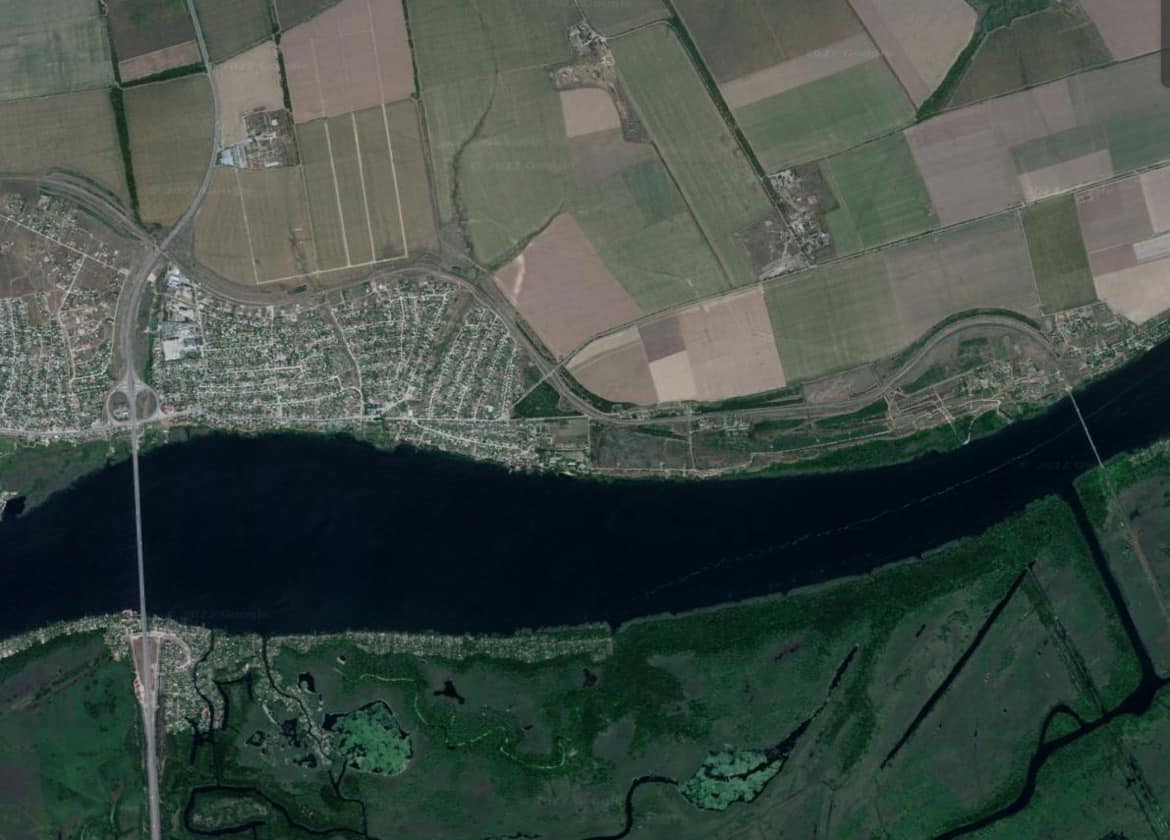
The image [below] is of the only 2 bridges coming from Kherson to the east bank of the Dnapier River. All of the estimated 60,000 people being evacuated have to cross them, so do Russian troops falling back from the city. The three plots of land in the field are Russian military bases. The airport to the west of the city is in Ukrainian hands according to Uri G., a Ukrainian that lives in back of the AMIC gas station in Antonivka. right next to the main bridge, in the northern suburb of Kherson. There’s been no electricity or running water for 5 days, it’s starting to get cold there at night The food in the stores is gone. Uri said he had enough food for his two daughters for 3 more days. No one is helping anyone in the city and he says people are really mad and scared because of all the explosions. So, the situation is pretty grim. Ukraine will take Kherson, but at what cost? Uri said that they are only letting Russian’s evacuate, the Ukrainians have to stay in the city.A “safe zone” has been setup by the Russians for the evacuees to go to in Lohistyk Yunion Tov RTS 11, it’s another military base east 3 miles of the bridge. The bridges are mined, he says the Russians are going to blow them up to stop the Ukrainians at the river.
This is the area of the Homiel Airport, 3 Km N of Belarus’s second largest city, Gomel which sits on the banks of the Sozh River, 30 miles N of the Ukrainian border at Chernihiv and 116 miles NNE of Kyiv. It is the home of Belarus national airlines “Belavia.by” and “AviaStar Cargo”. It sits due W of the Russian Border 26 m to the E, by the Russian cities of Vyshikov, Dobrodeevka and Krasnyl-Kamen, all within 5 m of the border with Belarus. This is a major corridor being used by the Russians to stockpile military supplies and launch air strikes from the Homiel Airport. It is the key railroad, surface road and air traffic artery for Russian forces.The airport suffered a mysterious attack within the last 96 hrs, 8 large explosions pretty much destroyed the whole airbase, and everything in it. Mums the word on who was responsible for the attack, but not, on the fact that Belarus was launching Russian MiG air attacks against Ukraine from the airbase. Furthermore, the large Dubetskoe slave labor prison complex sits right on the Russian border at Zlynka, the political prisoner torture facility is being used by the Russian to hold Ukrainian POWs.Some elements of the international CI believe that this area of Belarus is the assembly point for Belarus’ attempt to invade northern Ukraine at some point. Lukashenko better watch his ass, because the Ukrainian’s are not playing around, he wouldn’t stand a chance in a 1 on 1 battle with Ukraine.Even though Ukraine gets some arms from the West, not all, and some training, not all, some Intel, communications and other support, but again, not all, it’s the Ukrainian People that are the ones fighting and winning, they are the ones that are standing up, and even without support from the West, they would fight with sticks and rocks if they had to.
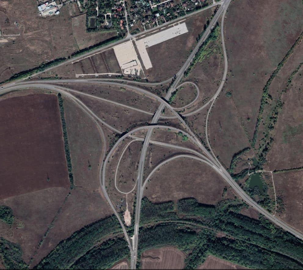
Okay, so I have to be careful what I say, and for the time being, I can’t give DGPS coordinates, or actual satellite images of any Russian military assets, without the Ministry of Defense for the Russian Federation crying like little babies, but it’s only a temporary setback.What I can do, is show you an image from a new Cesium Satellite Imaging System, called the Cesium Viewer. I like it but you must know your geography because there are no label to guide you, there is a layer for it, but the feature affects resolution, too much latency. I like it anyway because I can get right down to street level, and it’s near real-time.The image from 24 Sept 2022, 17:28:06 UTC, is of a really wild traffic nightmare 10 miles south of downtown Donetsk, an industrial city in eastern Ukraine on the Kalmius River in Donetsk Oblast. The population in the Donetsk metropolitan area is 2 million people.This is a vital intersection for Russian military logistics, and is currently being fiercely fought over. This incredibly interesting architectural and engineering feat is very confusing looking, but it’s the main arterial connection to the Russian border eastward to Povilo-Uspenka, and south to Mariupol and Shcherbarkova Russia. The intersection connects all the north, south, east and west regions of Ukraine.I’m trying to not be discouraged about being dressed down by my peep’s, of course I objected, which probably wasn’t one of my smoothest moves. So we’ll see, I’m still collecting intel, I just can’t share all of it. If anyone would like to voice their opinion about my being censored because the Russian Ministry of Defense is crying, this would be a good post to do it on.
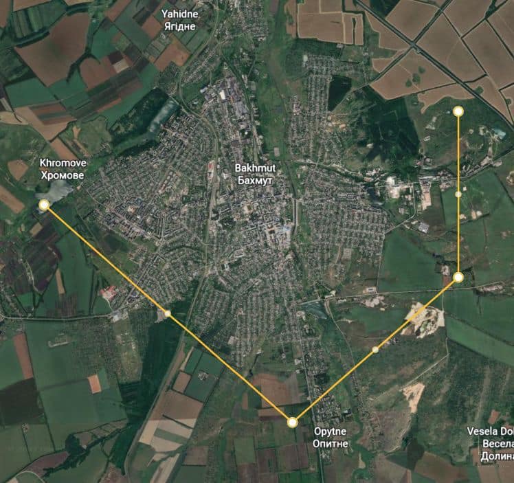
Russian Federation occupation forces composed of regular Russian army troops, Donbas Peoples Republic (DPR) separatist forces, Luhansk Peoples Republic (LPR) separatist forces, Chechen forces, and elements of the PMC Wagner Group, have launched an assault on Bakhmut in Donetsk Oblast, 41 miles SSE of Slovyansk. The invasion force is attacking from 3 sides, as indicated in the image, coming through Klishchivka from the SSW, Opytne from the S, and Pokrovske from the E. The civilian population is attempting to evacuate, the only avenue for escape is on the main highway 6 miles north to the crossroads south of Paraskoviivka to get the highway towards Slovyansk, 35 miles WNW in open country. It’s unclear if the highway, or the city of Slovyansk, is in Ukrainian control at the moment. There are several foreign correspondents that are stranded because their French counterparts went looking for a StarLink terminal and never returned. The situation is grim.For the time being, I will not be posting detailed situation reports on Russian military assets in theater, complications have developed and I have been well advised to temporarily suspend the operation, until the situation clarifies itself. However, I will continue to post as much content as the situation allows.
List of Russian military occupation codes to be mobilized in the first wave:
▪️ 100 – rifle units
▪️ 106 – military intelligence units
▪️ 107 – special purpose units and units
▪️ 113 – tank units
▪️ 121 – specialties of infantry fighting vehicles
▪️ 123 – specialties of tracked armored personnel carriers
▪️ 124 – specialties of wheeled armored personnel carriers
▪️ 125 – specialties of armored personnel carriers of airborne troops
▪️ 131 – specialties of artillery guns
▪️ 166 – engineering and demining units
▪️ 247 – specialties of on-board electronic warfare equipment
▪️ 878 – nurses
▪️ 879 – doctors
[Below] I’ve located the main Russian military’s attack helicopter base(45 42’02″N 35 25’07″E) south of Dzhankoi in Ukrainian-Crimea.There are 41 attack helicopters at the air base, more than any base I’ve seen to date. This image is fresh at 10:45 pacific time, Saturday, Sept. 17 2022. This is where the Russians are launching air strikes from that are hitting around Kherson on the north and east sides of the city.
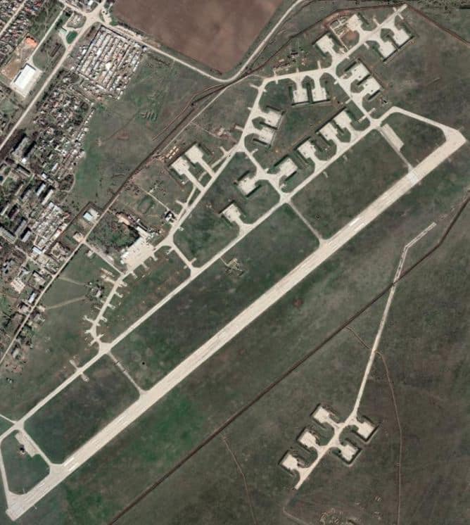
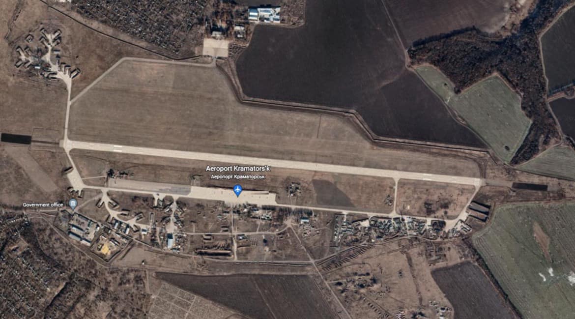
The Russians launched a counteroffensive at 06:00 19 19 Sept 2022 along an “L” shaped front with each leg 33 Km long. The Northern line starts 11 Km south of Slavyansk, Donetsk Oblast, at Kramatorsk (48 42’21″N 37 37’46″E) and runs S by SE 33 Km to Bakhmut(48 35’53″N 37 59’43″E) and from there the line runs due west 33 Km to Druzhkivka (48 37’04″N 37 31’37″E). The line is pushing north towards Slavyansk.The 1st DPR Slavyansk Brigade, Russian Reconnaissance Brigade and the PMC Wagner Group have engaged the Ukrainian Defense Forces with heavy artillery, rocket and mortar barrages and are using new tactics against the Ukrainians.Russian Forces are using Mavik-3 drones to check the fire from Vasilek 2B9 82 mm auto-mortars that can fire 120 rounds per minute and have a 4 round magazine along with 120 mm mortars, BM-21 Grad 122 mm MRLS rockets, Tomodo-S MRLS rockets and BTR-90 APCs with BMP-2 turrets. There is fierce combat taking place along the entire line.Below is an image of the Kramatorsk Airport (48 42’23″N37 37’27″E), the airport is heavily damaged with no aircraft visible, it appears to have been abandoned. The Slovianska Thermal Power Plant (48 52’19″N 37 45’55″E) has been destroyed by 2 Russian missiles. I’ll put the image in the comment.Neither one of these images are from today, my satellite feed is down, the airport image is yesterday and the power plant is last week. We work with what we’ve got.
